Kuchler GmbH Geomatics combines the many years of experience of the KUCHLER Group in the field of sewer inspection, sewer cleaning and sewer rehabilitation with modern drone-supported 3D recording. Our aim is to document hard-to-access areas such as sewers, manholes, culverts and special structures safely, efficiently and comprehensibly.
With systems such as the Flyability Elios 3, LiDAR-based data acquisition and digital evaluation, we create a reliable basis for condition assessment, planning and reporting. The focus is not on the technology for its own sake, but on its practical benefits for operators, local authorities, engineering offices, industry and infrastructure projects.
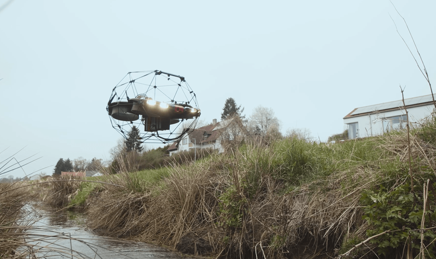
Drone-based inspection where conventional methods reach their limits
Modern technology based on real channel experience

The KUCHLER Group has extensive experience in the inspection, cleaning and rehabilitation of sewers and drainage systems. Kuchler Geomatics is expanding this expertise with modern methods for drone-supported recording and digital documentation.
The Flyability Elios 3 enables the inspection of suitable interior areas that are difficult to access from a safe distance. In addition, LiDAR-based 3D data and high-resolution image data can be recorded, processed and used for further technical evaluation.
This creates practical added value: less effort for areas that are difficult to access, better spatial traceability and a structured data basis for decisions.
Digital evaluation with a professional eye
Software-supported, structured and comprehensible

The image and 3D data captured during the inspection can be digitally processed and evaluated using software. Anomalies, damage, deposits or geometric changes can thus be documented in a structured manner and prepared for further evaluation.
The decisive factor remains the technical classification. Kuchler Geomatics does not see digital evaluation as a substitute for experience, but as a tool to make more efficient use of existing expertise. The results can be prepared for condition assessments, reports and suitable exchange formats.
Why Kuchler Geomatics?
Kuchler Geomatics stands for the combination of proven channel practice and modern digital recording technology. As part of the KUCHLER Group, we know the requirements from real projects: Accessibility, safety, documentation requirements, condition recording, rehabilitation planning and economic feasibility.
Our strength lies in not looking at new technologies in isolation, but integrating them into proven sewer inspection and condition assessment processes. This produces results that are not only technically impressive, but actually help in everyday project work.
Questions and answers about us
What does Kuchler GmbH Geomatics do in the field of drone-based sewer inspection and 3D recording?
Kuchler GmbH Geomatics combines the KUCHLER Group's many years of experience in sewer inspection, sewer cleaning and sewer rehabilitation with modern drone-supported 3D recording. The aim is to document hard-to-access areas such as sewers, manholes, culverts and special structures safely, efficiently and comprehensibly. Systems such as the Flyability Elios 3 and LiDAR-based data acquisition are used for this purpose. The captured image and 3D data is digitally processed and made available for condition assessment, planning and reporting. The focus is not on the technology alone, but on its practical benefits for operators, local authorities, engineering offices, industry and infrastructure projects.
What advantages does the combination of canal practice and digital surveying at Kuchler Geomatics offer?
The combination of proven sewer practice and modern digital surveying creates a reliable basis for well-founded decisions in everyday project work. Kuchler Geomatics does not view new technologies in isolation, but integrates them into existing sewer inspection and condition assessment processes. This produces results that are not only technically precise, but also practically usable. Particularly in areas that are difficult to access, the effort involved can be reduced and spatial traceability improved. At the same time, clients benefit from a structured data basis for documentation, assessment and further planning steps.
For which buildings and areas of application is Kuchler Geomatics suitable?
Kuchler Geomatics specializes in the project-related recording of interior areas that are difficult to access. These include manholes, culverts, collectors, sewer sections and special structures. Before each deployment, we check which technology is best suited to the situation in question. This ensures that precisely the data required for assessment, planning and further decisions is recorded. This practical approach supports local authorities, operators, engineering offices, industrial companies and infrastructure projects alike.
How is the captured image and LiDAR data analyzed at Kuchler Geomatics?
The image and 3D data captured during the inspection is digitally processed and evaluated using software. Anomalies, damage, deposits or geometric changes can thus be documented in a structured manner and prepared for further technical evaluation. However, Kuchler Geomatics does not see digital evaluation as a substitute for experience, but rather as a tool for more efficient use of existing expertise. The decisive factor remains the technical classification of the results in the respective project context. The processed data can then be made available for condition assessments, reports and suitable exchange formats.
What role does the Flyability Elios 3 play in the work of Kuchler Geomatics?
The Flyability Elios 3 enables the inspection of suitable interior areas that are difficult to access from a safe distance. It complements the existing expertise of the KUCHLER Group with a modern method of drone-supported recording and digital documentation. In combination with LiDAR-based data acquisition and high-resolution image data, a detailed and comprehensible data basis is created. This data can be processed and used for further technical assessment. In this way, the technology supports safe, efficient and practical documentation of complex structures.
Why Kuchler Geomatics drone-based sewer inspection and digital 3D recording?
Kuchler Geomatics is the right choice because it combines many years of sewer experience with modern digital recording technology. As part of the KUCHLER Group, the company is familiar with the requirements of real projects, from accessibility and safety to documentation obligations and renovation planning. New technologies such as the Flyability Elios 3 and LiDAR-based data acquisition are not used in isolation, but are integrated into proven processes in a meaningful way. This produces reliable, comprehensible and usable results for condition assessment, planning and reporting. Clients benefit from clear deployment planning, comprehensible documentation and clean processing of the inspection data.
Our claim
We want to make inspection data understandable, reliable and usable. That's why we pay attention to clear deployment planning, comprehensible documentation and clean preparation of the results.
Whether it's a manhole, culvert, collector or difficult-to-access section of sewer: we check which technology can be used on a project-specific basis and which data is required for evaluation, planning and further decisions.